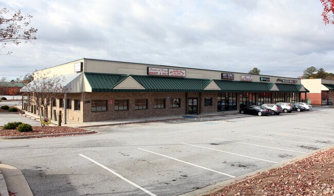
Property Record
534 Athens Hwy, Loganville, GA 30052

NEARBY LISTINGS FOR SALE OR LEASE
-
-
View all Loganville listings for lease on LoopNet.com
Property Detail
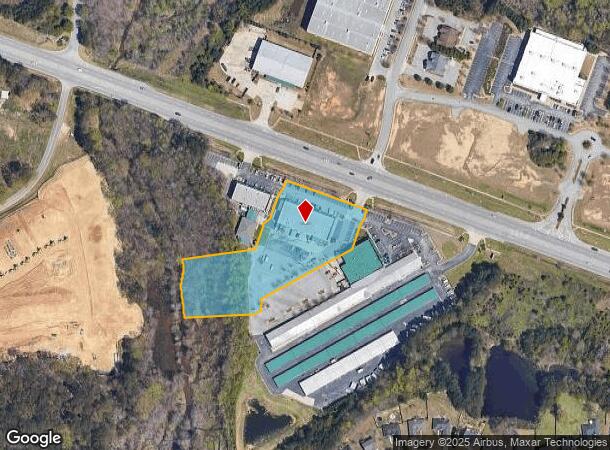
534 Athens Hwy
Atlanta-Sandy Springs-Roswell, GA
U S Hwy 78
5-131-008
TR 2 U S HWY 78
Stripcommercialcenter
Gwinnett
AE
Georgia
13297C0085E
131
2025
3.08 AC
2025
Lawrenceville/Dacula
050735
Atlanta
13,125 SF
DEMOGRAPHICS near 534 Athens Hwy
1 mile
3 mile
5 mile
2024 Total Population
7,232
49,718
114,312
2029 Population
7,741
52,985
122,130
Pop Growth 2024-2029
+ 7.04%
+ 6.57%
+ 6.84%
Average Age
36
37
38
2024 Total Households
2,240
15,876
36,711
HH Growth 2024-2029
+ 7.05%
+ 6.82%
+ 7.04%
Median Household Inc
$85,474
$87,526
$88,574
Avg Household Size
3.20
3.10
3.10
2024 Avg HH Vehicles
2.00
2.00
2.00
Median Home Value
$283,445
$290,391
$297,321
Median Year Built
2004
2001
2000
Nearby Places
Map Layers
Map Styles
 Street
 Aerial
Transit
 Traffic
 Biking
Places
Listings with unknown addresses are not visible on the map
- Restaurants
- Banks
- Shops
- Fitness
- Groceries
PUBLIC TRANSPORTATION
AIRPORT
Hartsfield - Jackson Atlanta International
Drive
Walk
Distance
Hartsfield - Jackson Atlanta International
58 min
38.2 mi
SALE & LEASE HISTORY
LISTING DATE
SALE/LEASE

Sep 25, 2016
For Lease
Sep 25, 2016
For Lease
Nearby Properties
Address
Land Use
TOTAL SIZE
Lot Size
Zoning
Address
Land Use
TOTAL SIZE
Lot Size
Zoning
455,030 SF
80.40 AC
R100
Address
Land Use
TOTAL SIZE
Lot Size
Zoning
349,060 SF
59.85 AC
R100
Address
Land Use
TOTAL SIZE
Lot Size
Zoning
194,295 SF
36.59 AC
R100
Address
Land Use
TOTAL SIZE
Lot Size
Zoning
222,622 SF
49.17 AC
R100
Address
Land Use
TOTAL SIZE
Lot Size
Zoning
189,254 SF
40 AC
R100
Address
Land Use
TOTAL SIZE
Lot Size
Zoning
4,408 SF
148.92 AC
R100
Address
Land Use
TOTAL SIZE
Lot Size
Zoning
186,309 SF
15.53 AC
RM
Address
Land Use
TOTAL SIZE
Lot Size
Zoning
133,375 SF
16.50 AC
CH
Address
Land Use
TOTAL SIZE
Lot Size
Zoning
3,261 SF
30 AC
RM8
Address
Land Use
TOTAL SIZE
Lot Size
Zoning
107,829 SF
7.82 AC
RM
Address
Land Use
TOTAL SIZE
Lot Size
Zoning
2,274 SF
15.82 AC
OI
Address
Land Use
TOTAL SIZE
Lot Size
Zoning
82,809 SF
21.79 AC
R100
Address
Land Use
TOTAL SIZE
Lot Size
Zoning
103,892 SF
17.44 AC
CH
Address
Land Use
TOTAL SIZE
Lot Size
Zoning
91,131 SF
15.60 AC
C2
Address
Land Use
TOTAL SIZE
Lot Size
Zoning
79,276 SF
9.08 AC
C2
Address
Land Use
TOTAL SIZE
Lot Size
Zoning
56,664 SF
5.35 AC
CH
Address
Land Use
TOTAL SIZE
Lot Size
Zoning
105,453 SF
14.57 AC
OI
Address
Land Use
TOTAL SIZE
Lot Size
Zoning
102,850 SF
10.03 AC
LI
Address
Land Use
TOTAL SIZE
Lot Size
Zoning
29,724 SF
24.45 AC
R100
Address
Land Use
TOTAL SIZE
Lot Size
Zoning
105,840 SF
2.66 AC
C2
Address
Land Use
TOTAL SIZE
Lot Size
Zoning
50,623 SF
18.47 AC
R100
Address
Land Use
TOTAL SIZE
Lot Size
Zoning
201,210 SF
27.11 AC
CH
Address
Land Use
TOTAL SIZE
Lot Size
Zoning
74,945 SF
12.99 AC
CH
Address
Land Use
TOTAL SIZE
Lot Size
Zoning
43.89 AC
MH
Address
Land Use
TOTAL SIZE
Lot Size
Zoning
137,401 SF
12.95 AC
CH
Address
Land Use
TOTAL SIZE
Lot Size
Zoning
65,747 SF
10.91 AC
R100
Address
Land Use
TOTAL SIZE
Lot Size
Zoning
83,286 SF
13.64 AC
C2
Address
Land Use
TOTAL SIZE
Lot Size
Zoning
101,130 SF
6.05 AC
C2
Address
Land Use
TOTAL SIZE
Lot Size
Zoning
34,130 SF
7.80 AC
R100
Address
Land Use
TOTAL SIZE
Lot Size
Zoning
14,784 SF
90.18 AC
R100
The World's #1 Commercial Real Estate Marketplace
Connect with us
© 2026 CoStar Group
The information above has been obtained from sources believed reliable. While we do not doubt its accuracy we have not verified it and make no guarantee, warranty or representation about it. It is your responsibility to independently confirm its accuracy and completeness. Any projections, opinions, assumptions, or estimates used are for example only and do not represent the current or future performance of the property. The value of this transaction to you depends on tax and other factors which should be evaluated by your tax, financial, and legal advisors. You and your advisors should conduct a careful, independent investigation of the property to determine to your satisfaction the suitability of the property for your needs.